Guest Blog
Top 10 Cheshire Walks from GPS Cycle and Walking Routes
GPS Routes have nearly 1000 cycle routes on their site, covering the whole of the UK's National Cycle Network in England, Wales, Scotland and Northern Ireland.
There's also the Cycle Routes Near Me Map where you can see a map of all the local routes and track your progress on your mobile phone. There are also over 3000 walking routes including all of the National Trails, most of the UK's long distance trails, easy waterside routes on our Canal Walks, challenging climbs on our Mountain and Hill Walks and exhilirating cliff top trails on the Coastal Walks. You can also see a collection of walks in your area on the Walks Near Me page.
They have kindly shared their top 10 Cheshire Walks with us.
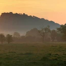
1. Delamere Forest
3.1 miles (5 km)
Enjoy miles of walking and cycling trails in this 2,400 acre forest on the Cheshire Plain, near Frodsham.
For walkers there's several easy waymarked trails to try. Cyclists can enjoy challenging mountain bike trails or easy family trails. The trails are well marked and cycle hire is available from TRACS (UK) situated just the left-handside of the forest centre car park. You can see details of all the trails on the open street map link below.
This circular walk starts from the Linmere car park and takes you around Blakemere Moss Lake. Look out for wildlife including greater spotted woodpecker, black headed gulls, dragonfly and various butterflies.
Several long distance trails pass the forest so it's easy to extend your exercise. You can explore the Mid Cheshire Ridge on the Sandstone Trail or head towards Warrington on the Delamere Way. The Baker Way also starts at the forest and will take you to Chester via Tarvin and the Shropshire Union Canal.
Just to the south of the forest you can climb to Eddisbury Hill where you will find an Iron Age hill fort. Eddisbury is the largest and most complex of the seven hill forts in the county of Cheshire. It's a short climb from the car park and affords great views over the forest and the surrounding countryside. Near here there's also Old Pale Hill which marks the high point of the northern mass of the Mid Cheshire Ridge. There's views over seven counties from this popular spot.
2. Sandstone Trail
31.7 miles (51 km)
This is a popular walk that runs through Cheshire and Shropshire from Frodsham to Whitchurch.
The path starts in Frodsham and heads south to Frodsham Hill with lovely views over the Cheshire Plain and the Mersey Estuary. You continue to Delamere Forest with its 2,400 acres of mixed deciduous and evergreen woodland and Blakemere Moss, a lake around 1 km in length.
From Delamere you continue south towards Beeston Castle in Tarporley. With an exhibition detailing 4000 years of the castle's history and 40 acres of woodland trails, Beeston is a major attraction on the walk. Soon after you will come to Peckforton Castle, which is actually a country house built in the style of a medieval castle. It is now used as a luxury hotel.
The path then heads through the lovely Peckforton Hills, passing the Bickerton Hills and Hampton Green before joining the towpath of the Shropshire Union Canal to Grindley Brook and then onto the finish point at Whitchurch.
To extend your walking on the trail you could try our circular walk from Frodsham which uses the Delamere Way to create a loop around the town.
3. Tegg's Nose Country Park
2.5 miles (4 km)
This lovely country park in Macclesfield has splendid views of the Peak District National Park and the Cheshire plain. You can also see Macclesfield Forest, the summit of Shutlingsloe (the second highest point in Cheshire), the Telecoms Tower on Sutton Common and the Macclesfield Canal. This circular walk starts at the car park at the northern end of the park and heads south to the viewpoints. At the southern end you'll descend to Teggsnose Wood, Tegg's Nose Reservoir and Bottoms Reservoir. There's some nice waterside trails to try here before returning to the car park on other footpaths on the eastern side of the park.
The landscape includes meadow, moorland and woodland while there is also a waterside section aroung Tegg's Nose Reservoir. The park has a very good Visitors Centre where you can find out details of the cycle and walking routes in the park. Click here to see the Tegg's Nose to Parkgate cycle route details.
The Gritstone Trail walking route also runs through the park so there is scope for continuing your walk. Macclesfield Forest and Trentabank Reservoir lie just to the east where you will find more good walking trails.
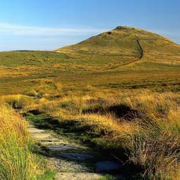
4. Shutlingsloe
3.1 miles (5 km)
Enjoy fabulous views over Cheshire on this climb to Shutlingsloe Hill in the Peak District. The distinctive hill is also known as the Cheshire Matterhorn due to its shape from certain directions.
The walk starts from the Trentabank Reservoir car park and follows a footpath through Macclesfield Forest to Shutlingsloe, passing Nessit Hill on the way. There is quite a steep path to the 506 m (1,660 ft) summit but you will be rewarded with splendid views of the surrounding Peak District scenery. At the summit you will find a toposcope detailing all the landmarks visible from the viewpoint. This includes Shining Tor and the famous large dish of the radio telescope at Jodrell Bank. You can return on the same path or descend to Wildboarclough and return on country lanes to make it a circular walk.
Highlights on the walk include nice woodland trails through the conifer forest and views over Trentabank Reservoir with its heronry and interesting plantlife
It's easy to extend your walking in this lovely area. You could head west from the car park to Ridegate Reservoir and pick up the Gritstone Trail and follow it to the excellent Tegg's Nose Country Park.
5. Alderley Edge
4.3 miles (7 km)
This lovely circular walk explores the beautiful National Trust owned area of Alderley Edge. Starting at Alderley Edge train station you climb to a sandstone escarpment, where there are fabulous over the Cheshire Plain to the Peak District. You return through a delightful wooded area, passing a waterfall, before arriving back at Alderley Edge train station.
The National Trust have also devised a number of other walking trails which you can pick up from the Wizard Tea-Room. These include the Miners Ramble which explores the age-old mining history of the Edge. The Wizard Trail also starts from the edge and will take you to the the Wizard's well, the 15th century Alderley mill and National Trust owned Hare Hill. You can follow a permissive path south to Hare Hill to extend the walk.
It's about a 1.5 mile walk south east from the edge and includes beautiful gardens with 70 varieties of rhododendron, azaleas, hollies, and hostas. The centrepiece is a walled garden containing a pergola and wire sculptures.
6. Gritstone Trail
34.8 miles (56 km)
This beautiful, challenging walk runs through the Peak District from Disley to Kidsgrove.
The walk begins at the train station at Disley and soon comes to the wonderful Lyme Park with its mansion house and Medieval deer park. You continue south passing the town of Bollington before climbing to the unusual structure of White Nancy and crossing the Saddle of Kerridge. From the elevated position above Bollington you can enjoy splendid views across the Cheshire Plain, the mountains of North Wales to the west, the hills of Shropshire to the south and the Pennines to the north and east. The route continues to the lovely Tegg's Nose Country Park via Tower Hill. The views are truly dramatic from this former quarry site, including Shutlingsloe, the second highest point in Cheshire.
The next section takes you on towards Rushton Bank before climbing the Bosley Cloud - at 1,125 ft it's a challenging section but the views of Congleton, Macclesfield and Greater Manchester are magnificent.
The path continues to Mow Cop with its ruined castle, before you join the Macclesfield Canal and then the Trent and Mersey Canal taking you to Kidsgrove.
7. Lyme Park
5.3 miles (8.5 km)
This is a circular walk through the splendid Lyme Park in Disley, Cheshire. Here you can explore the 1,300 acre estate with its resident deer and enjoy fabulous views of the Peak District. There are also tranquil lakes, peaceful woodland walks and an Edwardian rose garden to enjoy. The park may look familiar as it was used for the BBC production of 'Pride and Prejudice'.
The walk begins at the park gate near Disley train station, before exploring the most attractive areas of the park and returning to the start point.
The Gritstone Trail long distance path passes through the park so you could pick this up to extend your walk. Heading south will take you towards Bollington via Sponds Hill.
Additionally the North Cheshire Way passes through Lyme Park, so you could pick this up and head west towards the village of Adlington, passing the Macclesfield Canal on the way.
8. Three Shires Head
3.7 miles (6 km)
Explore this beautiful section of the Dane Valley and enjoy rivers, old stone bridges and waterfalls on this lovely walk in the Peak District.
Three Shires Head is a point on Axe Edge Moor where the counties of Cheshire, Derbyshire and Staffordshire meet. Here you will find a Grade II-listed packhorse bridge over the River Dane. The bridge is thought to have been constructed in the 18th century. It's a delightful area with a number of small waterfalls and the surrounding Peak District scenery to enjoy.
The walk begins from a parking area in Gradbach a couple of miles south of Three Shires Head. You then follow the Dane Valley Way and other footpaths to the bridge and the river. Here you will also find Panniers Pool, a popular place for a paddle or swim in the summer months.
An alternative route would be to come from Buxton and follow the Dane Valley Way across Axe Edge Moor to the bridge. This is a much longer walk but does pass through the pretty Buxton Country Park on the way. See the Buxton to Three Shires Head Walk page for more details.
To extend your walking in the area you could visit the fascinating Lud's Church. The deep chasm is located just to the west of the start point of this walk.
Just to the south you can climb to The Roaches.
This elevated rocky ridge, includes fascinating rock formations and wonderful views of the surrounding countrsyide. It is one of the most popular walks in the Peak District.
9. White Nancy
2.2 miles (3.5 km)
This walk climbs to unusual structure of White Nancy overlooking the town of Bollington in Cheshire. The folly is in the shape of a small domed sugar loaf and thought to have been built in 1817 by Colonel Gaskell as a monument to the Battle of Waterloo.
This circular walk makes use of the Gritstone Trail to take you from Bollington to the 280.5 metres (920 ft) high White Nancy before crossing the Saddle of Kerrridge to Kerridge Hill. From the elevated position above the town you can enjoy splendid views across the Cheshire Plain, the mountains of North Wales to the west, the hills of Shropshire to the south and the Pennines to the north and east.
It's easy to extend your walk by continuing along the Gritstone Trail to the nearby Tegg's Nose Country Park.
See the Teggs Nose to White Nancy Walk page for more details.
10. Shining Tor and Cats Tor
6.2 miles (10 km)
Climb to the highest point in Cheshire on this wonderful walk in the Goyt Valley.
The walk starts from the Erwood Hall Car Park at the southern end of Erwood Reservoir. The route then ascends to Shining Tor, passing the Errwood Estate with its old ruined hall and attractive woodland. The hall was built in the 1830s by Samuel Grimshawe with a 2000 acre estate consisting of farmland and woodland with azaleas and rhododendrons. You can see the Grimshawe's family cemetery and an attractive Spanish Shrine to the governess of the children at Errwood Hall. The estate is a popular start point for walks in the Goyt Valley.
At the 559 m (1,834 ft) summit of Shining Tor you can enjoy great views of the Cheshire Plain, Winter Hill, the city of Manchester and Jodrell Bank. On a clear day you can also see as far as Snowdonia.
The route then heads north along the ridge to Cats Tor and then on to Pym Chair. It's a lovely stretch of the walk with a good path leading along the ridge with views of Cats Tor and the surrounding Peak District hills and moorland. Pym Chair is another popular viewpoint with a car park. You could also start the walk from here if you prefer.
From Pym chair you descend back to Errwood Reservoir along a nice country lane before a final waterside section leads you back to the Errwood Hall car park.
If you would like to continue your walking in the area then you could pick up the Midshires Way which runs past the reservoir. You could actually start the walk from nearby Buxton and follow the Midshires Way to Shining Tor from there. The Errwood Reservoir and Fernilee Reservoir Walk also starts from the same location.
If you head north from Pym Chair then you would soon come to Windgather Rocks, a popular place for rock climbers.


Featured in this blog


11 Miles
Read More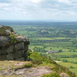
35 Miles
Read More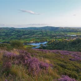
6.2 Miles
Read MoreArticles

Fetching your results
This should only take a few moments...

Post Date: 31st Jul 2026
Read More
Post Date: 29th Jul 2026
Read More
Post Date: 28th Jul 2026
Read More
Post Date: 27th Jul 2026
Read More
Post Date: 24th Jul 2026
Read More
Post Date: 23rd Jul 2026
Read More
Post Date: 23rd Jul 2026
Read More
Post Date: 23rd Jul 2026
Read More
Post Date: 22nd Jul 2026
Read More